THE VALLEY OF THE MOON MAIN STEM:
A Panorama in Space and Time
Created by Michael Acker
Main Stem: the main branch of a river. Nick-name applied to San Francisco’s Market Street.
Any main street.
The Valley of the Moon, sometimes called Sonoma Valley, was so named by General Vallejo, who probably mistranslated it from the Coast Miwok. Jack London, who lived there in the last years of his life (his ranch is now a wonderful California state park) used the name for the title of a novel.
Geothermal water was discovered (by Europeans. Native people surely used the waters previously) in the valley in the 1880’s. The area became a thriving resort spot, mainly for residents of summer-cold San Francisco, and continues to be to this day, although much has changed.
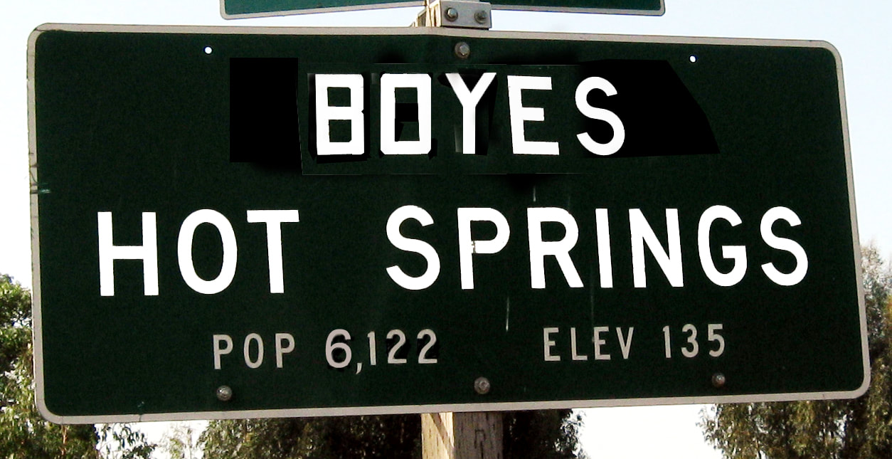
Long before I moved there (from San Francisco) I happened to take a drive down Highway 12 from Calistoga Rd. to the town of Sonoma. The setting, the buildings and the place names, Agua Caliente, Fetters Hot Springs, Boyes Hot Springs, El Verano, immediately and permanently enthralled me. Later I became acquainted with the history of the place, which furthered my fascination. I started to make art with and about my new home. Finally, I came up with this project.
With Ed Ruscha in mind, I photographed every building and lot on Highway 12 between Agua Caliente Rd and Verano Ave. I am creating a series of photo collage/watercolor panoramas. In addition to recording what is there now, I am incorporating photographs of buildings that are gone so that I can recreate the street as it would be if all had survived. If a lot or building were once the site of other buildings, the various layers would be presented above and below the panorama. I am also collecting historical information about the street, the buildings and people who built them and used them, which informs the visual work.
I want to capture the “ghosts” that inhabit this area and intertwine them with contemporary images. I love the idea that all these different eras can exist at once, at least in art. Since change is constant, this project could continue indefinitely.
The project is part historical document and part personal interpretation of images of the area in which I live, that I love, and that fascinates me. It is a celebration of the “order in complexity” of this particular built environment.
I have been an artist for 40 years. I have an MFA from San Francisco State. My work can be seen at mca-studios.com or by appointment.
Many thanks to the late Diane Smith of the Depot Park Museum, collector Gary Heon, historian Robert Parmerlee, and many others.
A note about the process: I take digital photographs that I compose in Photoshop, then print out on 140lb Arches watercolor paper. The images are collaged together, built up and painted on.
A PLEA TO ALL: If you have photographs or postcards of Sonoma Valley, of any era, and would consider loaning them to me, please contact me. THANKS!
A Panorama in Space and Time
Created by Michael Acker
Main Stem: the main branch of a river. Nick-name applied to San Francisco’s Market Street.
Any main street.
The Valley of the Moon, sometimes called Sonoma Valley, was so named by General Vallejo, who probably mistranslated it from the Coast Miwok. Jack London, who lived there in the last years of his life (his ranch is now a wonderful California state park) used the name for the title of a novel.
Geothermal water was discovered (by Europeans. Native people surely used the waters previously) in the valley in the 1880’s. The area became a thriving resort spot, mainly for residents of summer-cold San Francisco, and continues to be to this day, although much has changed.
Long before I moved there (from San Francisco) I happened to take a drive down Highway 12 from Calistoga Rd. to the town of Sonoma. The setting, the buildings and the place names, Agua Caliente, Fetters Hot Springs, Boyes Hot Springs, El Verano, immediately and permanently enthralled me. Later I became acquainted with the history of the place, which furthered my fascination. I started to make art with and about my new home. Finally, I came up with this project.
With Ed Ruscha in mind, I photographed every building and lot on Highway 12 between Agua Caliente Rd and Verano Ave. I am creating a series of photo collage/watercolor panoramas. In addition to recording what is there now, I am incorporating photographs of buildings that are gone so that I can recreate the street as it would be if all had survived. If a lot or building were once the site of other buildings, the various layers would be presented above and below the panorama. I am also collecting historical information about the street, the buildings and people who built them and used them, which informs the visual work.
I want to capture the “ghosts” that inhabit this area and intertwine them with contemporary images. I love the idea that all these different eras can exist at once, at least in art. Since change is constant, this project could continue indefinitely.
The project is part historical document and part personal interpretation of images of the area in which I live, that I love, and that fascinates me. It is a celebration of the “order in complexity” of this particular built environment.
I have been an artist for 40 years. I have an MFA from San Francisco State. My work can be seen at mca-studios.com or by appointment.
Many thanks to the late Diane Smith of the Depot Park Museum, collector Gary Heon, historian Robert Parmerlee, and many others.
A note about the process: I take digital photographs that I compose in Photoshop, then print out on 140lb Arches watercolor paper. The images are collaged together, built up and painted on.
A PLEA TO ALL: If you have photographs or postcards of Sonoma Valley, of any era, and would consider loaning them to me, please contact me. THANKS!
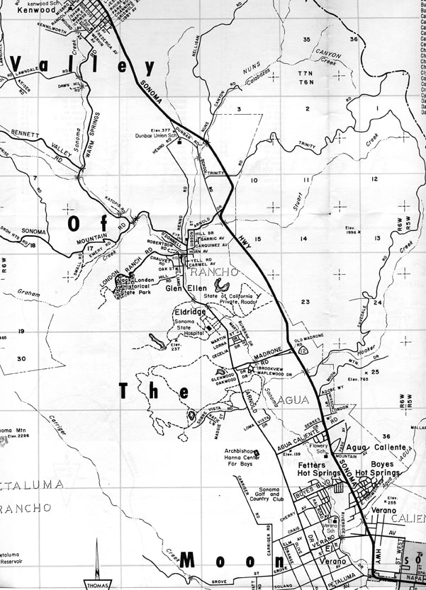
The collages are shown in geographical order in the Groups. The starting point is the intersection of Boyes Blvd. and State Highway 12, Sonoma County, California, 38°18'50.46"N, 122°28'54.25"W.
The numbering system is chaotic.
The numbering system is chaotic.
For many of the photographs, and many more, used in the Main Stem collages, see my book, The Springs, Resort Towns of Sonoma Valley: https://www.arcadiapublishing.com/Products/9781467124300
I have a lot of other bodies of work. You can see examples at mca-studios.com.
And go to springsmuseum.org/ and sign up for my history (and other topics) blog.
I have a lot of other bodies of work. You can see examples at mca-studios.com.
And go to springsmuseum.org/ and sign up for my history (and other topics) blog.
Copyright 2022 Michael Acker